Seaside Special - The Atlantic Highway: North Cornwall
The magnificently monikered Atlantic Highway invites almost as many Grand Tour images as last chapter’s The Night Riviera. The best section of the A39 – as it is known in everyday terms – creates a north-east/south-west axis between Blue Anchor Bay in Somerset and some of the more remote bits of Cornwall down to its junction with the A30 near Newquay. The route became the spine of an excellent trip last Summer to North Cornwall, as well as both the north Devon and Somerset episodes that follows this one.

The Cornwall trip started off with a tightly-wound five-leg public transport journey that merely emphasises the inaccessibility of that part of the country. When my 07.30am departure from Berko became hamstrung at Harrow and Wealdstone, I sensed that the area might remain inaccessible to me a little longer. A last-second decision saw me abandon the Euston-bound train there to jump the adjacent Bakerloo line by the width of a sliding door. We crawled through suburban north and west London, and I finally clambering out of the busiest covid-times tube I’d ridden onto a Paddington concourse thronging with masked-up travellers with the briefest of moments to catch the Exeter departure. Later, the Newton Abbot train was almost terminally becalmed on the eerie Somerset Levels. Thankfully the connecting Bodmin Parkway service was also running late. Swings and roundabouts.
In between stressful interchanges, there were some wonderful views to enjoy. I know this is a Cornwall post. And I’ve waxed on about the south Devon stretch already. Nevertheless, every time my train hits the Exe estuary and navigates the inlets and cliffs, I get a pang of joy. All the way to Teignmouth and then inland up the Teign estuary my nose was pressed hard against the window.
The Bodmin train took a route I’d not travelled before. At Plymouth I was intrigued to see a trio of empty, almost ghostly cruise ships moored out to sea, looking like a little collection of Dubai skyscrapers flipped through 90 degrees. Coronavirus had put cruise holidays on ice overnight. Pictures of the Diamond Princess’s transformation into a toxic pandemic petri-dish at sea still loomed over the industry.

Then over the magnificent Tamar on the high level bridge at Saltash, each bank lined with yachts and pleasure craft tied up to boardwalks, followed by a few more estuary crossings round the complicated waterways of Plymouth’s hinterland. Eventually we squirmed inland through narrow valleys and over undulating farmland. A dog, panting under his owner’s table across the aisle from me threw up on the floor. Even that didn’t spoil the mood. Thank God for face masks.
The bus journey from Bodmin Parkway was always going to be tortuous. A No 10 through-route exists, but only really if you are travelling in the morning, or on non-school days, or prepared to break your journey for an hour at Wadebridge. It is in that town, under a mid-afternoon downpour, that I cracked. After many hours on public transport I resorted to a taxi for the final 10 miles to port Isaac. This was a good decision. Not only was the driver a horse racing fan who’s brother-in-law was the semi-legendary, now-retired Middleham trainer George Moore, but he was also a keen photographer and directed me to some good vantage points.

And I explored them all…in between dodging horizontal hail blown in a spiteful north-easterly out of towering clouds zipping across the widescreen sky. Sheltering at the bottom of, Rose Hill, one of the narrowest (and most attractive) footpaths in the village (and there are many), the little bullets of ice still managed to find exposed parts of flesh. These interruptions didn’t last long though and it was amusing to see people blown sideways and umbrellas ripped from grasps by gusts that were given added impetus by the funnelling qualities of various alleyways and lanes. None of this would have been a surprise to the locals. This was June after all…

Dog walkers ruled in Port Isaac. My medium-sized mongrel would have been quite at home here. I met a couple of women herding a gaggle of Westies spread across the entire width of Fore Street, despite them being attached to diamante encrusted leads. I was chatting to the first woman as we were admiring the view and she shouted to her companion with a smile that she’d like my camera. The reply came back swiftly that it would be ‘just another excuse to dawdle’. I shouted back that my wife says the same when I’m forever stopping to take shots. ‘She’s not my wife!’ protested the second woman and then grinned to her dawdling friend, ‘Come along Fionnuala, don’t be making friends!’

Later in the day I spotted them down by the tiny harbour where I was outside the Mote Bar, sampling my first Doom Bar of the trip. They strolled past, still with dogs, but not recognising me. They had changed outfits. Fionnuala, tall and thin, was sporting a fine pair of white and gold plimsolls, whilst her smaller, more rotund friend tiptoed towards the sea in natty silver sliders.
Before dinner I’d walked up the southern flank of the hills enclosing Port Isaac, past the house belonging to Doc Martin in the tv series of the same name, round the headland and down to Pine Haven. The views back over the fishing village and as far as shimmering Tintagel Head made the climb easily worth the effort.


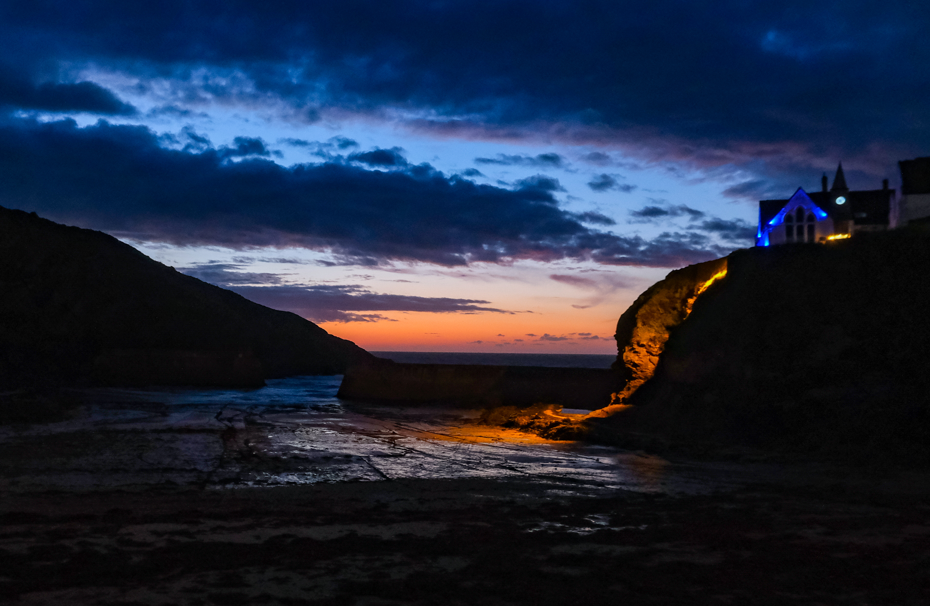
Away to the west lay more of north Cornwall’s jewels in the shape of Port Quin, Polzeath and the coast’s rock star, Padstow. I wouldn’t have time to visit them on that trip. I was headed north-east the next morning to meet up with my mate Ad. But first, a cauldron of moules mariniere awaited me in The Slipway Hotel, followed by a few sunset shots. In between the stinging showers, the skies had been clear and sharp. The evening did not disappoint.


Covid restrictions were still very much in force around the village. I had tried to grab a pint in the small, multi-roomed Golden Lion during one of the earlier rain breaks, but a safe-spaced table could not be found. After dark, once the day-trippers had departed, I had more success and was ushered to a spot in the small front bar where I joined casual conversation with the four other paying customers and the bar manager. Topics ranged through the slow post-covid tourist trade and the lack of Wi-Fi there at the bottom of the village which meant we all had to talk to each other. Clearly I hadn’t quite mastered this skill, because when asking to settle up I was instead presented with another beer. Oh well. The Tribute was a lively brew here. A creamy head and a nutty flavour, like real ale used to be before IPA got reinvented as some kind of sour USA West Coast mash.
The comment about slow trade was intriguing. Once I’d had my fill of Tribute, I wandered the tiny interlocking lanes around the harbour and found them thrillingly dark and quiet. There was music and chat from inside the pubs and hotels shoe-horned around the village, but not much else to encroach on the peace.
The full English at The Slipway was almost as good as the previous evening’s steaming mussels. I lingered over one last harbour view from my balconied room and then struck out on one of the most lung-bursting, thigh-stinging, wisdom-testing hikes I’ve ever undertaken.
I knew Port Isaac to Boscastle would be a fair step. Just over 13 miles, according to my research, but along the well-defined SW Coast Path and with some rewarding outlooks. A challenging enough route, I mused, but OK for an experienced walker such as myself (conjuring up untrustworthy memories of the London to Brighton walk). Had my research been a little less cursory, I might have seen the descriptors ‘severe’, ‘difficult’ and ‘strenuous’ which should have made me think twice.
In fairness, the weather turned what would have been a good yomp in to an epic exertion. The rain started earlier than forecast as a steady drizzle at Port Gaverne graduating to persistent downpours by Pigeons Cove. My old fashioned rucksack with three days of kit stashed inside hung increasingly deadweight off my shoulders, soaking up liquid faster than Guinness drinkers at the Cheltenham Festival.
None of this takes anything away from the experience of being up close and personal with the wild north Cornwall coast. Fantastically named caves, coves, sea views, valleys and streams came and went on the route from Port Gaverne to Tregardock and Trebarwith Sands. I scrambled up, sank into and variously blew hot and cold around Castle Rock (the main headland), Cartway Cove, Tresungers Point and Rams Hole. A rickety boardwalk across marshy ground took me near the cave of St Illickswell Gug and then on to Bounds Cliff, across fields to Ranie Point and down the valley at the chasm of Barret's Zawn.

The path across cliff tops afforded the best views but also obscured the number of back-to-back gulleys and valleys between me and my immediate target of Tintagel where I had vaguely arranged to meet Ad. Climbing up to Delabole Point and back down into Dinnabroad Valley, I can’t deny a sense of dispiriting frustration as another climb immediately presented itself up to the National Trust owned Dannonchapel.
I commend the SW Coast Path as a route that never ducks the issue. Not once did that thin strip of mud and shingle head inland to bypass a gap. Ravines came one after another as I surmounted one steep-sided bank only to plunge back down another. The irony is that if the path hadn’t been such a (well-maintained) helter-skelter of body-breaking climbs it wouldn't get close enough to so many soul-filling seascapes and mesmerising wave action. Sometimes you have to get deep down and dirty with the environment to extract the best experiences. That's what I kept telling myself anyway as I screamed 'Oh for fuck’s sake!’ when another ridiculous ascent swung in to view.

High above Tregardock Beach and Trebarwith Sands I was taking a break and managed to catch a single tremulous bar of phone signal. About 10 messages from Ad popped across my rain splattered screen. I was just about to answer one, giving my approximate location and a potential meet up point, when I heard ‘Alright then Dave!’ I don’t know how he had done it, but Ad had stumbled upon me in the middle of nowhere, preceded by his bounding Alsatian dog, Albus.
Ad had moved down from Raynes Park earlier in the year to set up a holiday cottage business above Boscastle. He’d taken the bus over to the Sands and worked his way back down the coast path ‘til he found me. He said ‘The plan was fool-proof unless you veered off the coast path!’ All the more remarkable when you consider that Ad is visually impaired (and that I’m not your regulation fool).
We struck out for Tintagel. Albus leading the way. Or sometimes bringing up the rear. Or maybe under our feet. I should have strapped my Fitbit to his off-fore leg. My stats would have been through the roof.
Tregardock Beach was a little hidden gem. A gorgeous golden sandy beach backed by imposing cliffs at low tide, it disappeared completely at high tide under waves pounding the Devonian rock. The isolation of some of the wild places on this coastline gave them the greedy appeal of secrets to be kept from the tourist masses. Trebarwith Strand and its good looking pub, The Port William, was another.
Much of the coastline here and on towards Tintagel had been the site of slate quarries. The Cornwall Calling website describes quarrying in the area from the late 1400's through to the last closure in 1937.
We peered over the cliff edge to see angular remnants of chiselled rock above slate waste creating blow holes and eddies for the incessant grey waves. The drops were sheer. In 1886, three men were killed when the rock they were drilling, snapped off and took them into the sea below.
Cornwall Calling again: ‘Slate was taken to Tintagel Cove. A boat would be moored below the cliffs, and a derrick perched on the cliff edge would be used to load slate. A wharf was also constructed at Penhallic Point where the cliff edge was cut back to form a 100ft vertical face. Ships would lie against this cliff in the natural deep-water berth, and the slate would be lowered by crane.’
There wasn’t time to sightsee around Tintagel Castle. And I’m not sure the English Heritage officer wanted to let two bedraggled humans and a shaggy-wet Alsatian onto her island anyway. Nevertheless, the castle and headland had dominated the horizon ever since I left Port Isaac on this walk several hours (weeks?) earlier. Even up close the headland struck me as one of those potentially overhyped landmarks that actually lived up to expectations. It was staggeringly monumental even in that rain-soaked guise.
The push from Tintagel to Boscastle was really hard. Further, wetter and more vertical than either Ad or I had anticipated. Two of the ravines: Bossiney Haven and Rocky Valley were properly treacherous. The rain by then was so hard it was running off the cliffs and down the paths like open sewers carved into the sedimentaries. Flint slabs had been wedged into the slopes on some sections to create steps, but over time their planes had shifted and added to the hazardous experience. I can only remember once before feeling actually concerned about any walk I’d ever undertaken. That was on the Five Sisters of Kintail where the sheer drops of over 3,000 feet adjacent to the path gave me vertigo. Here the fall might have been less severe, but the risk of it actually happening felt more real.
And yet, and yet… At the top of both sides of Rocky Valley, we stopped to take in the special views. That tension again between risks and rewards; between wild beauty and inaccessibility.
I did topple over a couple of times where the paths had become nothing more than mud slides. My partially-sighted mate did not falter once. Take from that what you will.

The path lurched east and we dropped into the narrow estuary where Mill Leat disgorges into Boscastle Harbour. My head was filled with images of the flash flood in 2004 that tore through this valley and destroyed or damaged over 100 village structures. We passed the Harbour Light tea rooms, originally a three-hundred year old building that was smashed up in the flood by a car being flushed down the valley. The shop was rebuilt from the ground-up to its original design.
 |
| Courtesy Polrunny Farm Cottages |
All the while we were ticking off impossible ravines and cliff navigations, Ad kept whispering about the final hill out of Boscastle up to his new gaff. All the while I thought it couldn't be as bad as those which we had stoically overcome. He was right though. That relentless mile-and-a-half steepness through the lovely village of Boscastle and up the ridge was tough because it came so close to our final destination. The lane criss-crossed a tributary of the Mill Leat and again I imagined the terrifying force of a flood screaming down those steep roads. Indeed I must have stopped about half a dozen times to ponder such happenings. Nothing at all to do with giving my burning thighs some brief respite.
Following his relocation to the south west, Ad and his partner Mel were now the proud owners of Polrunny Farm sited where the land begins to level out above the village. The site had a splendid aspect almost due north down the Jordan Valley and over Boscastle into the Atlantic. From the breakfast garden out front it was pretty much next stop Pembrokeshire, somewhere way over the horizon.
 |
| Courtesy Polrunny Farm Cottages |
I couldn’t deny a little envy at Ad’s set up, despite all the hard work it entailed. Breaking free of the 9-5 commuter grind is one thing, but to do so in such a fantastic location is quite another. Phil and Kirsty would be impressed. And I can’t recommend the cottages more highly. Especially the shower, under which I steamed for a good 20 minutes until I’d washed away the physical residue of north Cornwall’s elemental environment. Ad never mentioned how long it took him to clear the grit out of the plug hole.
After donning some dry-ish clothes found in a Tesco bag lurking at the bottom of my rucksack, we headed down the hill to find some grub. The Napoleon Inn was now Ad’s local. Another cause of mild envy. Decent food, good ale and, that night at least, sea shanties. The Boscastle Buoys are a local group riding the wave of a renewed interest in male harmony groups, led most notably by The Fishermen’s Friends. This lot were excellent. The landlord told us that he’d had to get a special licence, in those dark Covid times, for a public performance and, technically at least, no standing was allowed. To get a view and a proper listen from our back room, we undertook a few more trips to the bar and to the loo than might have been strictly necessary. The beers had a temporary restorative effect on my aching limbs and I managed the walk back up to Polrunny without stopping.
Ad showed me round Boscastle the next morning. ‘This is where I go gigging’ he declared. ‘Oh, I was gonna ask about the music scene’, I replied, looking around for a venue. Ad chuckled and pointed to some boats tied up by the harbour. They were gigs belonging to the Boscastle and Crackington Pilot Gig Club. Ad and Mel had recently joined the club to race these 32 foot long, six-oared rowing boats out on to the open sea. Traditionally used for pilotage, harbour work and as lifeboats, they looked narrow, precarious and hard work to me. Good luck to them.

Boscastle had plenty going for it aside from the sea and boating activities. There was a grounded, practical air about its shops, pubs and cafes that avoided some of the more charmless tourist guff of other towns and villages around the Cornish coast. Walking down from Polrunny Farm to the harbour, I was struck by bits of genuine community life, like the busy-ness round the school and nursery and even the number of people Ad fell into conversation with down the road. He always was a gobby sort though. (Insert cheesy grin emoji.)
I left Ad and Albus at the bus stop on the bridge and climbed aboard the No 95 service to Bude, reflecting on an eventful couple of days and a top catch up with an old mate.
Back on and off the Atlantic Highway, A39. The bus was busy and wove between the main road and various villages on the coast. Crackington Haven was popular with the passengers and I could see why. The bus descended a tight lane from sandstone uploads that reached a narrow cove revealing a pub, some cafes and a sandy beach at low tide. The cove is hemmed in by some of the highest cliffs in Cornwall. Having picked up a few more passengers, the bus departed by an even more hair-raising route up to Coxford and thence back to the A39.
Widemouth Bay was the opposite. As the name suggests, its long, open bay of soft sand was backed by gently sloping hills on which the modern village was grouped: bungalows, hotels and beach shops. The bus followed the coast as development increased steadily on the approach to my final stop on this tour, Bude.


Bude. Put it on the list. Lovely open beach, dramatic headlands, rock pools, rambling countryside, and a smuggling and sea-trading heritage. These are undeniably top quality geographic and historical bones about which to hang the flesh of a fine seaside town. Now I’m gonna sound like a Visit Cornwall advert. But it’s hard to deny the appeal of a settlement large enough for decent facilities, independent shops, an amazing café on the beach where I gorged on an enormous fry-up; but small enough to feel relaxed, laid back and not overrun with Newquay-type giant bronzed surfers whose entire purpose in life is to make me feel inadequate.
In Bude I felt adequate. I can think of no higher praise!
Series navigation: Intro and chapter guide
Previous episode: South-West Cornwall
Next episode: Poets' Corner: North Devon


Comments